The doodle honors the life of American geologist and oceanographic cartographer Marie Tharp, who contributed to the validation of continental drift theories.
Why is Marie Tharp being celebrated?
The world’s conceptions of the ocean were changed by the revolutionary ocean maps that American geologist and oceanographer Marie Tharp produced.
On November 21, 1998, Tharp was recognized for her outstanding work by being named one of the finest cartographers of the 20th century.
Early in the 1950s, when most of the undersea land was difficult to locate, Tharp’s career began. Tharp was credited with developing the first accurate scientific map of the rifted geology of the Atlantic ocean floor before the invention of underwater cameras.
Tharp was hired as the first female employee of the Lamont Geological Observatory in 1948.
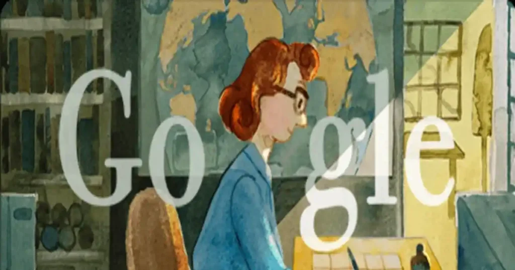
Tharp’s Google Doodle
The Google doodle’s watercolor design offered a very engaging and interactive story about Tharp’s achievements and challenges along the way.
The warm tones of blue and yellow matched the audio-visual doodle.
The animation, which is narrated by Caitlyn Larsen, Dr. Tiara Moore, and Rebecca Nesel, prompts you to click the next button after each section of the story.
There are also some things to do in the doodle to keep your interest.
Marie Tharp: Who was she?
Mary Tharp was born in 1920, in Ypsilanti.
Her father, a US Department of Agriculture employee, supported her by giving her a head start in learning how to make maps.
The University of Michigan awarded Tharp a master’s degree in petroleum geology.
Tharp relocated to New York City in 1948, where she went on to accomplish a great deal.
She was hired at the Lamont Geological Observatory as the first female employee, where she also met geologist Bruce Heezen.
Tharp’s Discoveries and Contributions
The Google Doodle cleverly illustrated how Heezen contributed his amassed data on ocean depths in the Atlantic Ocean and Tharp used them to produce maps.
She accomplished this using recent echo sounder results. In the end, she managed to locate the Mid-Atlantic Ridge.
The first map of the North Atlantic ocean bottom was co-published in 1957 by Tharp and Heezen, demonstrating that plate tectonics and continental drift were no longer simply theories and that the seafloor was unquestionably expanding.
Twenty years later, National Geographic released “The World Ocean Floor”, the first map of the entire ocean floor made by Tharp and Hazen.
The doodle also referred to Tharp’s 1995 gift of her complete map collection to the Library of Congress.
The observatory where she began her work presented her with the first Lamont-Doherty Heritage Award in 2001.
Also Read: Chris Hemsworth Take Break From Acting Due To Alzheimer’s Disease
Google honors Marie Tharp, an American geologist and oceanographic cartographer who contributed to the validation of continental drift theories. He contributed to the world’s first ocean floor map. The Library of Congress recognized Ms. Tharp as one of the greatest cartographers of the 20th century on November 21, 1998.
An interactive biography of Ms. Tharp has been included in today’s Google Doodle. Her story is narrated by three well-known women, Caitlyn Larsen, Rebecca Nesel, and Dr. Tiara Moore, who are actively continuing Marie Tharp’s legacy by making strides in the traditionally male-dominated fields of ocean science and geology.
A special and interactive Doodle on Google’s homepage today honors the life of American geologist and oceanographic cartographer Mary Tharp.
Caitlyn Larsen, Rebecca Nesel, and Dr. Tiara Moore provide descriptions for all the doodles.
On July 30, 1920, Mary Tharp, an only child, was born in Ypsilanti, Michigan. Her father, who worked for the U.S. Department of Agriculture, introduced Ms.
Mr. Hazen collects information about ocean depths in the Atlantic Ocean, Thanks to fresh information from echo sounders, a type of sonar used to assess sea depth, she discovered the Mid-Atlantic Ridge.
However, when they compared these V-shaped cracks to seismic epicenter maps, Mr. Heezen was unable to ignore the truth. Ms. Tharp and Mr. Heezen simultaneously published the first map of sea level in the North Atlantic in 1957. Twenty years later, “The World Ocean Floor,” the first map of the entire ocean floor made by Ms. Tharp and Mr. Heezen, was published by National Geographic.
Ms. Tharp donated the entire collection of maps to the Library of Congress in 1995. During the 100th anniversary celebration of its Geography and Map Division, the Library of Congress recognized her as one of the most inThe doodle honors the life of American geologist and oceanographic cartographers Marie Tharp, who contributed to the validation of continental drift theories.